Geocoding and Reverse Geocoding
FREE 1000 requests/month
€0.001 + VAT
FREE requests
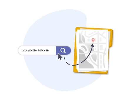
Transforms a street address into geographical coordinates and vice versa. Everything via API. Geocoding service available for 196 countries, with high precision mapping.
The Geocoding service allows you to convert street addresses into geographic coordinates (latitude and longitude) in real-time or convert geographic locations into addresses (reverse geocoding). The Geocoding service is available in over 196 countries and is designed to handle a high volume of requests per second, making it perfect for large-scale applications.
Geocoding
The Geocoding service, as mentioned earlier, allows you to convert an address or a point of interest into precise geographical coordinates.
The parameter requires passing the information: address.
REQUEST EXAMPLE
POST /geocode
The Geocoding service does not require passing any parameters in the endpoint
https://geocoding.openapi.it/geocodeThe payload must include the address data to be converted into coordinates. The address should be formatted as follows: [street], [city] [postal code] [country].
 {
   "address": "Via Cristoforo Colombo, Roma RM"
   }
RESPONSE EXAMPLE
POST /geocode
The response will include the geographic coordinates corresponding to the specified address, along with additional information about the location:
{
   {
  "success": "true",
  "elements": {
    "id": "v442c6653ee93a5733e8a9ea2f842cd5c250d2b6ab",
    "element": {
      "providedBy": "google_maps | openstreetmap",
      "latitude": 41.808916,
      "longitude": 12.4535602,
      "bounds": {
        "south": 41.7691104,
        "west": 12.3831487,
        "north": 41.8731993,
        "east": 12.4985637
      },
      "streetNumber": "null",
      "streetName": "Via Cristoforo Colombo",
      "postalCode": "04019",
      "locality": "Roma",
      "subLocality": "null",
      "adminLevels": {
        "1": {
          "name": "Lazio",
          "code": "Lazio",
          "level": 1
        },
        "2": {
          "name": "Citta Metropolitana di Roma",
          "code": "RM",
          "level": 2
        },
        "3": {
          "name": "Roma",
          "code": "Roma",
          "level": 3
        }
      },
      "country": "Italy",
      "countryCode": "IT",
      "timezone": "null"
    }
  }
}
Reverse Geocoding
Starting from the geographic coordinates - latitude and longitude, you can obtain the address.
REQUEST EXAMPLE
POST /reverse
The Reverse Geocoding service also does not require passing any parameters in the endpoint.
https://geocoding.openapi.it/reverseThe payload must include the geographic coordinates to be converted into an address. The coordinates should be formatted as follows: "lat": "
{
   "type": "coordinates",
   "lat": 41.289294,
   "long": 13.2349029
}
RESPONSE EXAMPLE
POST /reverse<
The response will include the complete address along with additional information about the geographic area:
{
  "success": "true",
  "elements": {
    "id": "v442c6653ee93a5733e8a9ea2f842cd5c250d2b6ab",
    "element": {
      "providedBy": "google_maps | openstreetmap",
      "latitude": 41.808916,
      "longitude": 12.4535602,
      "bounds": {
        "south": 41.7691104,
        "west": 12.3831487,
        "north": 41.8731993,
        "east": 12.4985637
      },
      "streetNumber": "null",
      "streetName": "Via Cristoforo Colombo",
      "postalCode": "04019",
      "locality": "Rome",
      "subLocality": "null",
      "adminLevels": {
        "1": {
          "name": "Lazio",
          "code": "Lazio",
          "level": 1
        },
        "2": {
          "name": "Metropolitan City of Rome",
          "code": "RM",
          "level": 2
        },
        "3": {
          "name": "Rome",
          "code": "Rome",
          "level": 3
        }
      },
      "country": "Italy",
      "countryCode": "IT",
      "timezone": "null"
    }
  }
}
Geocoding is the ideal solution for developers, tech companies, logistics services, and anyone needing to manage geographic data accurately and efficiently.
Do you need help?
Haven't found the answer you're looking for?
Fill in all the details, we will get back to you as soon as possible!
Geocoding is a service that allows you to convert an address or a location description (e.g., "Via Roma 10, Milan") into precise geographic coordinates such as latitude and longitude in real-time. This is useful for pinpointing a specific location on a map, facilitating operations such as navigation and digital map management.
Reverse Geocoding, on the other hand, performs the opposite operation: it converts geographic coordinates (latitude and longitude) into a readable address or location description, such as a street name, city, or specific area.
The Geocoding service is available for 196 countries with high-precision mapping.
The Geocoding service returns the following information based on an address or geographic coordinates (latitude and longitude):
- Request ID
- Provider
- Latitude and Longitude
- Boundaries (North, South, West, East)
- Street Number
- Address Name
- Postal Code
- City
- 3 Administrative Levels (e.g., Region, Province, City) with information such as level, code, and name
- Country and Country Code
The Geocoding service is designed for companies in sectors such as logistics, real estate, food delivery, and those that need to locate a specific point on a map, simplify navigation route visualization, and manage digital maps.
Yes, through Openapi’s APIs, you can access over 28 services dedicated to the real estate sector:
- ZIP Codes (CAP)
- Municipalities Search
- Start and Advanced Municipalities
- Provinces, Regions, and Metropolitan Cities
- Suppressed Municipalities
- Geocoding and Reverse Geocoding
- Start and Advanced Real Estate Quotations (SMQ)
- Data on Real Estate Transactions (RMV)
- List of Properties from Cadastral Identifiers or Address
- National Property Search and Property Search Person
- Cadastral Property Data
- Cadastral Report
- National Mortgage Inspection
- Mortgage Inspection by Property and by Subject
- Mortgage Inspection of a Single Note
- Cadastral Plan
- Planimetric Document
- Cadastral Map Extract
- Lease Contract Registration, Cancellation, and Extension
These services are available through different APIs: Docuengine, Cadastre, Real Estate.
Geocoding allows you to access data from top services like HERE, Google Maps, and Open Street Maps with a single request. The Geocoding API will provide the best result in a few seconds.
The data is returned in real time.
Data is returned in real-time.
The service costs start at €0.01, with 1,000 free requests per month.
Carbon free energy for Our Cloud ![]() Low CO2
Low CO2


© 2024 Openapi SpA, a single-member company, under the direction and control of Open Holding Srl.
Viale Filippo Tommaso Marinetti 221 - 00143 Rome - Business Register: 1378273, Share Capital: €50,000.00, VAT Number: IT12485671007, Recipient Code: 'USAL8PV' - Certified Email: 
Openapi is certified in: Quality System **UNI EN ISO 9001:2015** - Data Quality **ISO 25012:2014** - Security Management **ISO/IEC 27001:2022** - Geneder Equality According UNI PdR 125:2022
All prices are net of any VAT, stamp duty, registration fees, or other taxes that may be due. All logos listed on the portal are copyrighted and owned by their respective owners.


